Transform Survey Data Into Intelligent 3D Underground Models
From field data to intelligent 3D utility models—accurate, clash-free, and BIM-ready
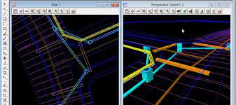
We transform underground utility survey data into detailed 3D models using 12d Model, a leading civil engineering and BIM platform. Our models help engineers, designers, and contractors visualize buried infrastructure, detect clashes, and streamline planning—reducing risk and rework.
What We Deliver
3D utility networks with pipe sizes, materials, and invert levels
Attribute-rich models including service types, depths, and ownership
Clash detection with proposed infrastructure and existing services
IFC, DWG, and GIS exports for seamless integration with BIM and CAD workflows
Geo-referenced outputs aligned with local coordinate systems
Why It Matters
Improves design accuracy and reduces costly surprises on-site
Supports digital twin creation for long-term asset management
Enhances collaboration across engineering, utility, and construction teams
Speeds up approvals with clear, visual documentation
Complies with BIM, GIS, and local authority standards
Our Workflow
Data Collection: We gather utility data using GPR, EM, and topographic surveys
Data Processing: Survey data is cleaned, validated, and attributed
3D Modeling: Utilities are modeled in 12d with full metadata and connectivity
Quality Control: Models are reviewed for accuracy and compliance
Delivery: Final outputs are provided in BIM, CAD, and GIS-compatible formats