

Ground Penetrating Radar (GPR) Services – See Beneath the Surface with Confidence
Your Trusted Partner for Accurate – Precision Underground Imaging Without Excavation
Accurate Subsurface Detection across the Kingdom of Saudi Arabia and GCC
Recon Consulting Services – provides cutting-edge GPR surveys to construction firms, engineers, and government agencies. Our non-destructive technology reveals what lies beneath – from buried utilities to structural defects – preventing costly surprises and keeping your projects on schedule.
What is GPR?
Ground Penetrating Radar (GPR) is an advanced geophysical method that uses high-frequency radar pulses to create detailed images of subsurface structures. It’s safe, non-destructive, and ideal for:
- Utility Locating (metallic & non-metallic pipes/cables)
- Concrete Scanning (rebar, conduits, voids)
Why Our GPR Services Win More Business
Unmatched Precision & Reliability
- 96% Detection Accuracy – Locate utilities, voids, and rebar with confidence
- Latest GPR Systems – Multiple antenna frequencies for any depth (5cm to 25m+)
- Real-Time Data – Instant insights, reduced project risks.
Industry-Leading Expertise
- Technicians – 10+ years average field experiences.
- 1,000+ Successful Projects – From small residential scans to major infrastructure
- Compliant with PAS 128:2014 & ASCE – 38-22 – Your assurance of quality
- Tailored for Gulf Conditions
- Integrated Solutions
Actionable Results
- Real-time data interpretation
- Custom reports with annotated radargrams, 3D models, and site maps
- Fast turnaround (24–48 hrs for urgent projects)
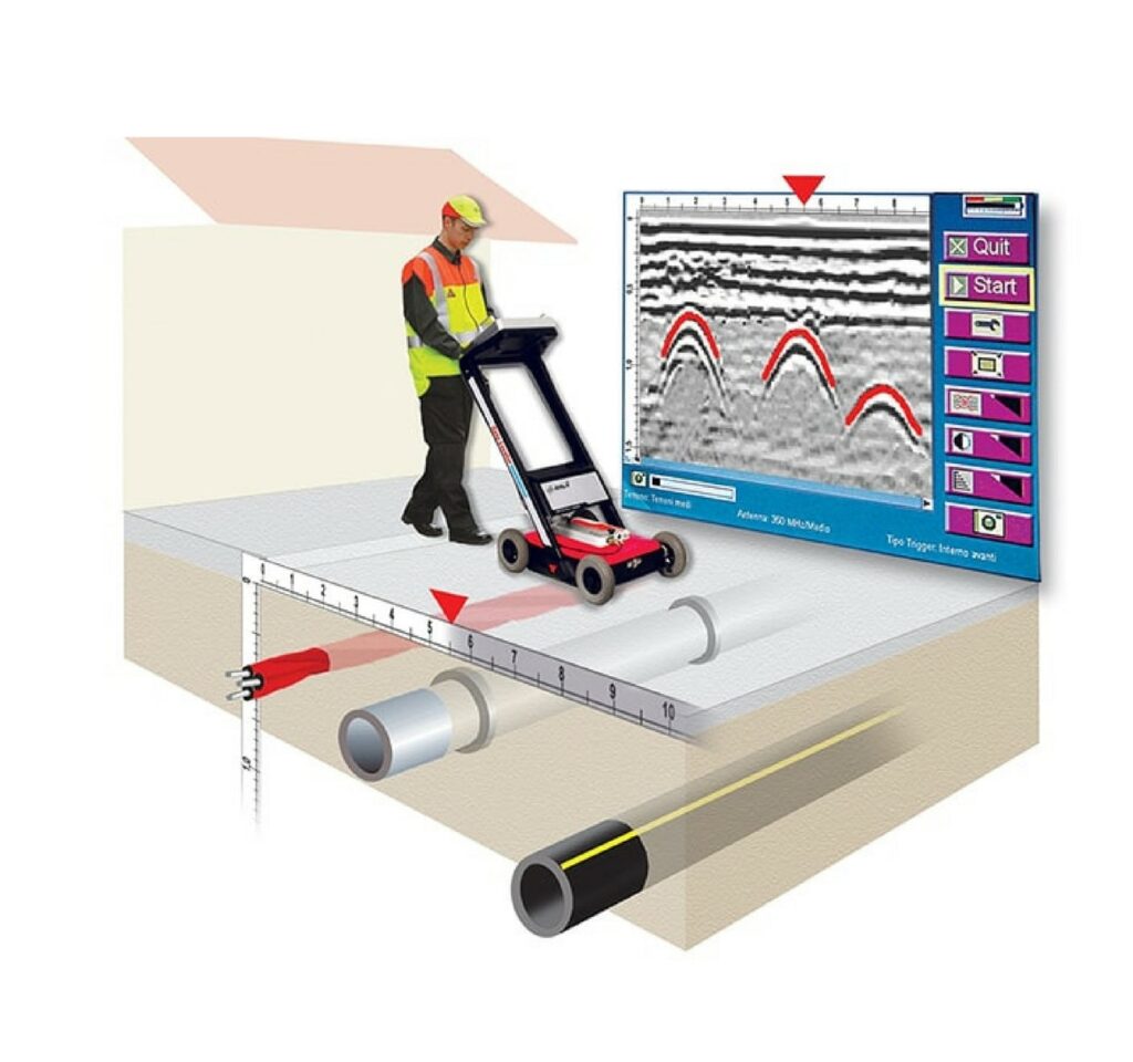
How GPR Works
- Antenna emits radar pulses into the ground.
- Reflections occur at boundaries between materials (e.g., soil vs. pipe).
- Receiver captures reflected signals to generate subsurface profiles (radargrams).
Key Parameters:
Frequency:
- High (500 MHz–2.6 GHz): Shallow scans (e.g., concrete, utilities).
- Low (10–400 MHz): Deep penetration (e.g., geology, archaeology).
Depth Range: From <1m (concrete) to 30m+ (low-frequency in dry soil)
Frequently Asked Questions About GPR Surveys
What is Ground Penetrating Radar (GPR)?
GPR is a non-destructive geophysical method that uses radar pulses to image subsurface structures like utilities, voids, rebar, and soil layers. It’s safe, fast, and works on soil, concrete, asphalt, and ice.
How deep can GPR detect?
- Concrete scans: Up to 24″ (60 cm) with high-frequency antennas.
- Utility locating: Typically, 3–15 ft (1–5 m) in normal soils.
- Geological surveys: Up to 100 ft (30 m) with low-frequency antennas in dry conditions.
Can GPR detect plastic pipes?
Yes! GPR detects non-metallic utilities (PVC, clay, fiberglass) if they’re filled with water or surrounded by contrasting soil. Dry plastic pipes are harder to detect.
Is GPR safe near high tension electrical lines?
Absolutely. GPR emits less energy than a cell phone and won’t interfere with utilities or harm personnel.
How accurate is GPR?
- Horizontal accuracy: ±1–3 inches (2–7 cm) for shallow targets.
- Depth accuracy: ±10–20% (e.g., a target at 3 ft may be ±3–7 inches).
Accuracy depends on soil conditions and antenna frequency.
What can GPR find?
- Metallic & non-metallic utilities
- Rebar, post-tension cables, and voids in concrete
- Underground storage tanks (USTs)
- Graves, archaeological features
- Sinkholes and soil layers
What can’t GPR detect?
- Pure metals (e.g., solid steel beams) – they reflect all signals.
- Objects in clay or saltwater-saturated soils (high conductivity blocks signals).
- Very deep targets (>30 m) – alternatives like seismic surveys may be better.
How long does a GPR survey take?
- Small residential site: 1–2 hours.
- Large commercial project: 1–2 days.
Data processing and reporting add 24–48 hours.
Do you provide markings or maps?
Yes! We deliver:
- CAD/GIS-compatible maps
- Radargrams (cross-sections)
- 3D models (for complex sites)
- Physical markings (spray paint or flags) if needed.
Why choose GPR over potholing or X-rays?
Method | Cost | Speed | Accuracy | Damage |
GPR | $$ | Fast | High | None |
X-Ray | $$$$ | Slow | Very High | Radiation risk |
Potholing | $$ | Medium | Medium | Destructive |
GPR is the best balance of cost, speed, and safety.
Can GPR work in wet conditions?
Light rain: Yes. Heavy rain/flooding: No – water interferes with signals.
Do I need a GPR survey before digging?
Legally required in most areas! Avoid utility strikes, fines, and injuries.
How do I prepare my site for GPR?
- Clear surface debris.
- Provide old utility maps (if available).
- Mark areas of concern.